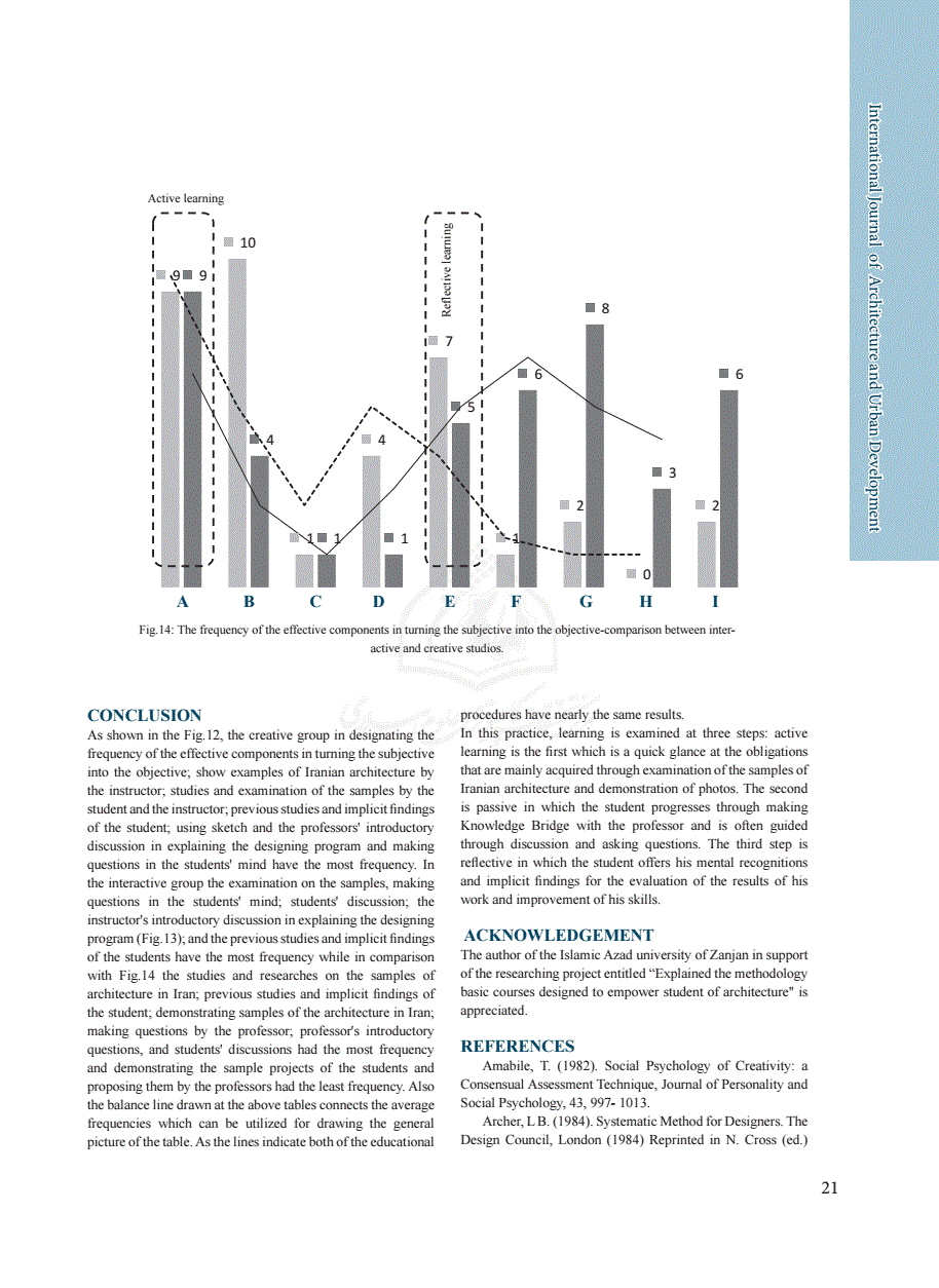
چکیده:
This paper reviews the experience of Persian designers and planners for creating the most livable
and greenery capital city in the hole region of Middle East throughout the 17th Century. New concepts of urban green development emerged in that time. Some of these ideas where extremely creative and vanguard from there era and still some of them are the main theoretical basics of urban green planning in the modern world. This paper focuses on Isfahan’s greenway planning ideas and discusses how the city transformed to a sustainable city in Safavid period. The discussion is based on the combination of the organic and planned forms of greenway design, which was unique by that time and made the garden city of Isfahan. The Maddies1, which are the branches of water derived from the river and flowed inside the urban context, are studied as the bases of organic greenway and the Charbagh2 and Naghshe-Jahan Square are investigated as the planned green developments.
خلاصه ماشینی:
"The Maddies1, which are the branches of water derived from the river and flowed inside the urban context, are studied as the bases of organic greenway and the Charbagh2 and Naghshe-Jahan Square are investigated as the planned green developments ABSTRACT: .
, 2012) The essential structure of Isfahan in the Safavid period can be described by two major axes of development: first, the north- south axis alongside the old backbone of the city, which was formed alongside the main chains of the bazaar and extended through Charbagh Avenue to the south of the river; and second, the east-west axis alongside the Zayande river and its artificial branches, or Maddies.
, 2012) The essential structure of Isfahan in the Safavid period can be described by two major axes of development: first, the north- south axis alongside the old backbone of the city, which was formed alongside the main chains of the bazaar and extended through Charbagh Avenue to the south of the river; and second, the east-west axis alongside the Zayande river and its artificial branches, or Maddies.
(Fig. 6) Charbagh Greenway Outlining the orientation of the royal city, the Zayenderud Fig. 6: Schematic map of Isfahan’s water channel (Madi) system, the Maddies made an organic design in the city (Ardalan & Bakhtiar, 1973) created natural east west axis, crossed by the Chahar-Bagh Avenue, which was divided by the Shah-jub; the main canal in its center and stretched from north to south."