Abstract:
حوضۀ آبخیز گزازچای به عنوان یکی از زیرحوضههای رودخانۀ قزلاوزن در ارتفاعات تالش شامل مجموعهای از نهشتهها و لندفرمهای با ماهیت، سن و موقعیتهای متفاوت است. این حوضه بخشی از تاریخ طبیعی کواترنر ارتفاعات یاد شده را در خود جای داده است. بازشناسی این تاریخ و اشکال و لندفرمهای دیرینۀ شکل گرفته در بستر زمانی و مکانی آن هدف اصلی پژوهش حاضر را تشکیل میدهد. این پژوهش از لحاظ روش از نوع بنیادی است که تجزیه و تحلیل آن بر پایۀ روش تحلیلی استوار بوده و طی آن عوامل و متغیرهایی مورد پژوهش قرار گرفتهاند که حداقل از کواترنر تا عصر حاضر به ویژه در طول هولوسن در شکلزایی حوضه تاثیرگذار بودهاند. تراسهای زمینساختی در طبقات متفاوت ارتفاعی، نهشتههای دریاچهای سدی هولوسن با تناوب دورههای آبوهوایی خشک و نیمهخشک تا مرطوب، توالی عمودی نهشتههای رودخانهای در لابلای نهشتههای دریاچهای و نمود آنها به صورت یک سطح بازمانده، نهشتههای پوششی و قرارگیری آنها بر روی نهشتههای دریاچهای و زمینلغزش دیرینه مهمترین اشکال و لندفرمهای موروثی در سطح حوضه هستند. شکلگیری این اشکال و لندفرمهای موروثی ارتباط مستقیمی با فرارفت سطح حوضه و فرونشست سطح اساس ناحیهای آن یعنی حوضۀ کاسپین جنوبی دارد. مهمترین تاثیر این فرارفت متروک ماندن تراس های زمینساختی به عنوان بخشی از سیسم گزازچای و اختلاف ارتفاع زیاد آنها با بستر کنونی رودخانه است. بدین ترتیب در طول تکوین حوضه برتری با فازهای کاوشی بوده است.
Introduction From the Quaternary period to the Neolithic age of the West Asian Region, which covers a wide range of Iran, it has undergone numerous environmental changes. In general, with respect to the natural history and environmental changes of the Quaternary region of the Middle East, which includes Iran and West-Asian, some researchers believe in the theory of cold and dry phases during glacial and warm and humid periods in interglacial periods. What is important to day and almost universally agreed is the coincidence of cold and dry weather-phase phases, with glacier conditions and wet phases, with the interglacial periods of the northern hemisphere. The Gizaz-chay watershed as one of the sub-watersheds of the Gezelozan River and one of the subsystems of the Baghrodagh mountains comprises a assemblage of deposits and landforms of varying nature, age and position in the landscape. This watershed is home to a part of quaternary's natural history that has embraced Tallesh Mountains. Recognition of this history and palaeolandforms formed in its temporal and spatial context was the main purpose of this study. MethodologyThis research is empirical in terms of the method of analysis, which is based on the analytical method, in which factors and variables have been investigated which have influenced at least Quaternary up to the present time in the dynamics of the area surface. The physical instruments used include the topography map 1: 50000 and of geological map 1:100,000 kivi, aerial photographs 1: 550,000 satellite images taken from the Google Earth site. To determine the coordinates of identifiable forms and paleolandforms at the catchment area and transfer them to the map and the GIS environment, GPS has been used. In order to provide a chronological framework for reconstructing the history of long-term climate changes and evolution landscape of the basin during the Quaternary, the age-depth model presented for 13500 years of Neor lake (located 20 km north of the Gazakhshay Basin) Based on the core 7.5 meters from the southern lake peats. Results and discussionAlthough the Gizaz-chay watershed is presently from semi-arid and semi-humid weather conditions, the evidence of clay and brown silt layers in the lava cuttings of the temporary lagoon sediments belong to the Holocene, almost wet conditions It shows the present climate. Salt and clay-green clay layers with sandy interlayers can be interpreted as an index of colder and wetter conditions by reducing evaporation and higher lake levels. These layers represent a low-energy sedimentary environment with colder and humid climate conditions. Vertical sequence of river deposits along the lake deposits can be attributed to the lake recurrence due to dry and semiarid climate conditions, along with reduced rainfall and increased runoff energy. In such a situation, coarse sediments are transported to distant distances and are located on small-scale lake deposits. ConclusionThe most important palaeogeomorphic evidence in the Ghizaz-chay Khalkhal basin is the following: Tectoinical terraces on different altitudes, lake sediments with the periods of dry and semi-arid to humid, Vertical sequence of river deposits along the lake's deposits and their appearance as a residual surface, covering deposits and their placement on the lake's deposits and the paleolandslide of the Neyakhoram.The lack of deposits with the origin of the large flood stream at the bottom of the dam, the gorge form of the Gazakhach River, as well as the large width of the natural dam consisting of trachytic volcanic rocks, suddenly disrupts is reject. The formation of these forms and heritages landforms has a direct link with uplift movements and subsidence Caspian Sea. The contining drop in regional base level as a result of subsidence of the Caspian Sea has driven incision and aide in the retention of the terrace deposits as they have been abandoned as the Ghizaz-chay systems have eroded downward. This way during evolution of the watershed has been predominance with erosive phase.
Machine summary:
در اين پژوهش از ميان شواهد ياد شده به دليل وجود تراس هاي رودخانه اي و زمين ساختي ، نهشته هاي درياچه اي و همچنين نمودهاي حاشــية يخچالي به عنوان اشــکل ديرينه و موروثي که به طور کلي از آن تحت عنوان ژئومورفولوژي ديرينه ياد مي شــود، به منظور شــناســايي خلاءهاي شــناختي موجود و گشــودن ديدگاه ها و چشــم اندازهاي جديد براي پژوهش هاي ديرينه محيطي و آب وهوايي آينده ، در اين حوضه مورد بررسي قرار گرفته است .
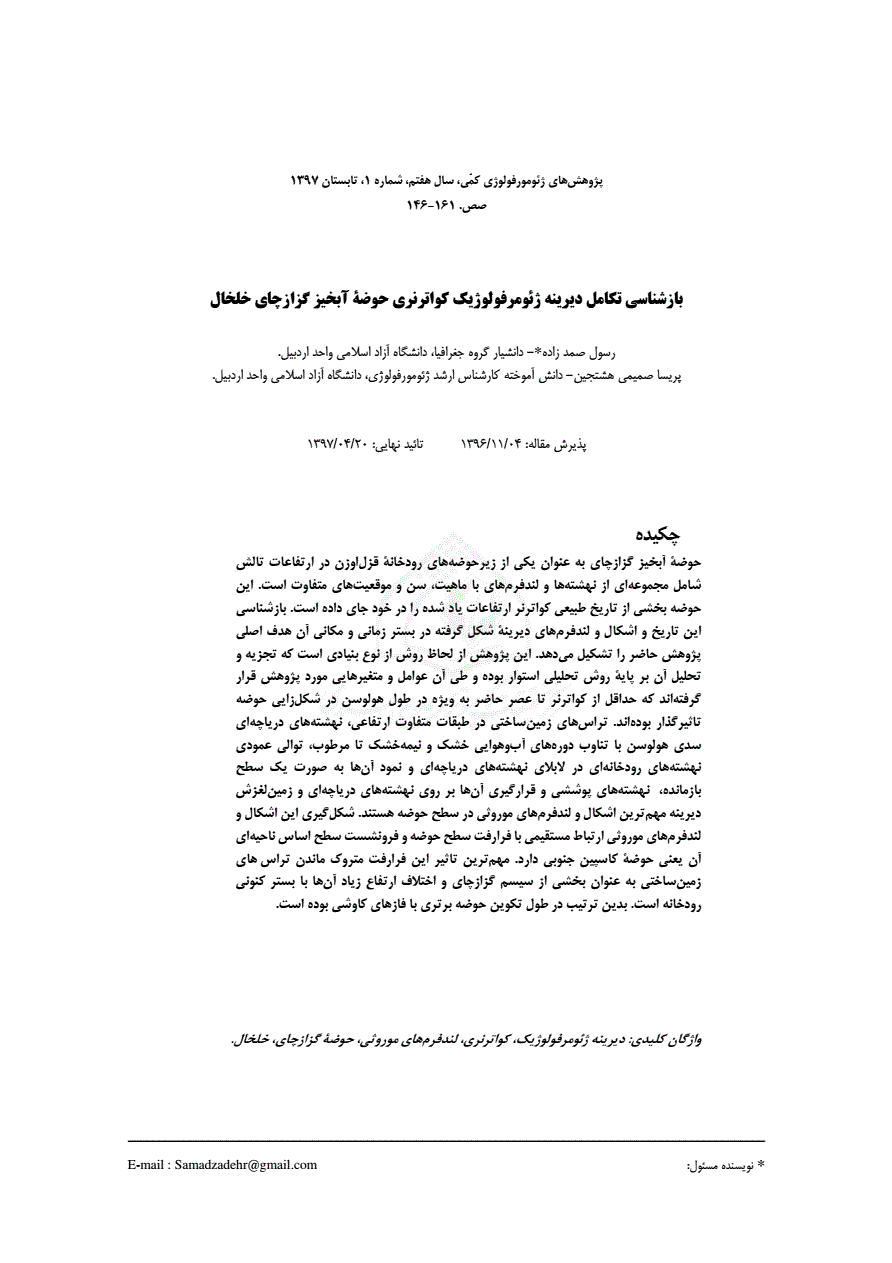
(به تصویر صفحه مراجعه شود) شکل ٨ : سطوح بريده شده بر اثر فرارفت منطقه واقع در شمال دشت ترزنق (آبان ١٣٩٥) زمين لغزش ديرينۀ نياخرم هر چند که در سطح حوضة گزازچاي به دليل گسترش سنگ هاي آتشفشاني هوازده ائوسن ، اوليگوسن و مجموعه هاي ر سوبي ميو سن زمين لغزش هاي متعددي وجود دارد، ولي مهم ترين آن ها که در روند شکل زايي و همچنين خلق يکي از اشکال مورثي حوضه تاثيرگذار بوده است ، زمين لغزش ديرينة روستاي نياخرم مي باشد ( شکل ۹ ).
با در نظر گرفتن عمق بريدگي ۴/۵ متري نهشته هاي متناوب رودخانه اي ــــ درياچه اي توسط رودخانة گزازچاي و در نظر گرفتن آهنگ بريدگي ۰/۹ ميلي متر سالانه ، بريدگي اين تراس ها تقريبا ۴۰۵۰ سال پيش از عصر حاضر شروع شده و امروزه به شکل کنوني در آمده است .
Nature and implications of Quaternary climatic changes in Iran.
A late Pleistocene long pollen record from Lake Urmia, Iran.
Sea-level changes and neotectonics: an introduction', Journal of Quaternary Science, 17: 385-386.